


In late-April 2017, Donald Trump appeared to have lingering insecurities about the legitimacy of his election. It was not entirely irrational: the Republican had badly lost the popular vote, and he’d benefited from illegal Russian intervention and a highly dubious move from then-FBI Director James Comey. The president was obviously in office, but many saw an asterisk.
It was against this backdrop that Trump sat down with some reporters from Reuters, and he interrupted a discussion about China to hand out blue-and-red copies of the 2016 electoral map.
“Here, you can take that, that’s the final map of the numbers,” the president said from his desk, handing copies to each of the three reporters in the room. “It’s pretty good, right? The red is obviously us.”
All of this came to mind again yesterday — which is to say, nearly three years into Trump’s presidency, long past the point at which this map should be a point of preoccupation.
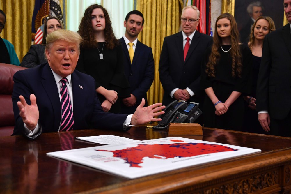
As Chief Justice John Roberts was being sworn in to oversee that affair, Trump was a few miles away, surrounded by a group of students and teachers who were there to praise him for waging war on secularism in schools. In front of him on the Resolute desk was a map that appeared to divide the country into a red/blue map based on the 2016 election results.
Trump, however, did nothing with the map. It just sat there in front of him, unmentioned, for the entire half-hour event.
It’s worth emphasizing a few relevant details. First, the map had nothing to do with the subject at hand, and it was not referenced at any point during the Oval Office event, at least not during the portions seen by the public. Second, the map is wrong: it purports to show county-by-county results, but it shows a variety of counties that Hillary Clinton won in red. It doesn’t even get the popular vote right: the map says the Democrat won by 1.1 million votes, when the actual margin was 2.8 million.
Third, even if it reflected county-by-county results accurately, it would still be misleading, because it would suggest land masses matter more than actual American voters. Many of those counties have a lot of square miles and very few people, which necessarily creates a distorted image. But even if we put all of that aside, the question that’s harder to answer is why in the world the map was there in the first place. It’s possible, if not likely, that Trump was trying to make some kind of convoluted point about his impeachment, as if the map was some kind of validating totem that leaves him immune to accountability for abuses and alleged crimes. This is a foolish argument that crumbles under scrutiny. But it’s also possible that the map and its ubiquity is an extension of the same insecurities that plagued Trump in early 2017. Maybe he wants to be popular and respected, and the map serves as a substitute for actual support.
Steve Benen is a producer for "The Rachel Maddow Show," the editor of MaddowBlog and an MS NOW political contributor. He's also the bestselling author of "Ministry of Truth: Democracy, Reality, and the Republicans' War on the Recent Past." Recommended

