


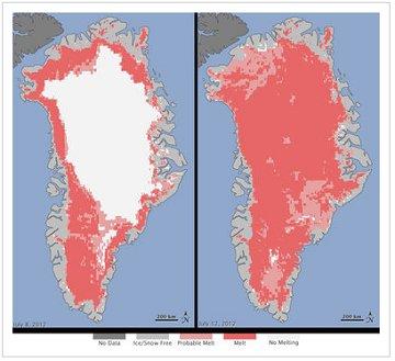
The picture posted to the right shows two images: Greenland on July 8 and Greenland four days later. Satellite imagery found that 97% the land mass experienced an unprecedented thaw that seemed literally impossible.
A NASA published a statement yesterday, quoting Son Nghiem of NASA’s Jet Propulsion Laboratory in Pasadena, Calif., who was analyzing radar data last week when he noticed that most of Greenland appeared to have undergone surface melting. Nghiem said, “This was so extraordinary that at first I questioned the result: was this real or was it due to a data error?”
It now appears this was not an error at all. The NASA piece added, “This extreme melt event coincided with an unusually strong ridge of warm air, or a heat dome, over Greenland.”
Lora Koenig, a NASA glaciologist who helped analyze the satellite data, said, “If we continue to observe melting events like this in upcoming years, it will be worrisome.”
I’ll go out on a limb and say it’s already worrisome.
Don’t worry, though, Republican policymakers have a plan: they’ll bury their heads in the sand and pretend the climate science is either non-existent or part of a communist plot. Former Rep. Bob Inglis (R-S.C.) predicted this week his party is bound to wake up one of these days, and will have no choice but to address the crisis eventually. “You can hold back the facts only for so long and eventually they overwhelm you,” he said. I wish I shared his optimism, but looking at the above image, and watching Republicans continue to insist there is no problem, I’m afraid facts are losing.
The place for in-depth analysis, commentary and informed perspectives. Recommended

