


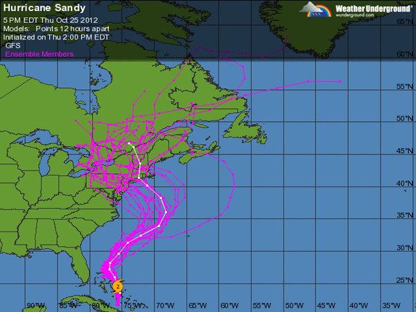
If you’ve looked at the the forecasting models for Hurricane Sandy, like the ones above on Weather Underground, you’ve no doubt noticed the hard left turn in the track that has meteorologists expecting an impact in the northeast U.S. It almost looks like an afterthought. At 35°N latitude it looks like a sure bet for “out to sea” and then, suddenly, the fake out move back to the coast. So what’s going on there?
And what’s more, what’s this business of it lingering for so long? The AP today explains that it just won’t leave, quoting NOAA forecater Jim Cisco, “It’s almost a weeklong, five-day, six-day event.”
The National Weather Service, in coining the “Frankenstorm” designation for Sandy characterizes the whole system as a “hybrid vortex” that includes an “amplifying polar trough” and a “high degree of blocking from eastern North America across the entire Atlantic basin.” High degree of blocking?
Luckily, a line from yesterday’s Metropolis blog at the Wall Street Journal (which is going with “snor’eastercane”) gave me a lead on what to look up…
“An increasingly negative NAO pattern is forecasted to become much stronger than normal, which will bring a near halt to the normal west-to-east movement of storm systems across the U.S. That more than anything else will open the door for Sandy to be sucked back towards the East Coast.”
NAO is North Atlantic Oscillation.
It turns out there is a semi-permanent low pressure spot around Iceland called “the Icelandic Low” and there’s a corresponding semi-permanent high pressure spot around the Azores called “the Azores High” (ahem… middle of the Atlantic, kind of the same latitude as Portugal).
A positive NAO means the Icelandic Low is especially low while the Azores High is especially high. When that’s the case, cold air over Canada moves right across toward Iceland (via the prevailing westerlies, which for some reason I associate with Vikings). BUT, we’re looking at an increasingly negative NAO that is expected to be especially strong. Negative NAO means that low over Iceland is not so low and the high over the Azores is not so high, so “strong” in this case means much less contrast between the low and the high.
This is where things get a little less intuitive for me, but apparently without the strong low pressure to motivate those westerlies, cold Arctic air just builds up over Canada. I keep seeing the word “blocking” but it seems more passive than that. A better way of saying it is that it “decreases the pressure gradient across the North Atlantic. This decreased pressure gradient results in a slackening of the westerlies.”
Anyway, that cold air makes its way down across the U.S. to the southeastern states via lower-than-average pressure (this is the trough part of the explanation) and the northeastern states end up with an especially snowy winter.
What you don’t usually have is a hurricane sitting right in the middle of it all. But knowing the dynamics at play, it’s easier to see how Sandy is hooking back to land and lingering for lack of any strong winter westerlies to push it away. If I may add, separately, it’s interesting to see the relationship between the North Atlantic Oscillation and the Arctic Oscillation. Last time I took a deep dive on weird weather (See: Why is Seattle getting all of my snow?), Arctic Oscillation figured prominently in that explanation as well. It’s weird that we are generally familiar with the Jet Stream and El Nino and La Nina (and newly, a Derecho) but we don’t often hear about these oscillations even though they seem especially relevant. It’s worth pointing out that we do sometimes hear about the Bermuda High. As far as I can figure, the Bermuda High is the same semi-permanent high pressure that defines the Azores High, and what it’s called depends on where it is over the Atlantic. Not linked in the text but also helpful, Wikipedia on NAO, which includes perspective on the effect on weather in Western Europe. As ever, your expertise in this is likely greater than mine, so any further insight you can offer is appreciated. Weather is so complicated, with so many variables, I realize it’s simplistic to single out this particular feature. I’m particularly frustrated that I can’t find a map of pressure over the Atlantic that clearly shows the North Atlantic Oscillation. I get this far and then I’m not sure what I’m looking at anymore. Is that because Tony is swirling around out there?Recommended

