


Over the weekend, Donald Trump published a tweet that included Alabama among the states “most likely be hit (much) harder than anticipated” by Hurricane Dorian. Twenty minutes later, the National Weather Service, while not referencing the president specifically, published a tweet of its own, telling the public, “Alabama will NOT see any impacts from Dorian. We repeat, no impacts from Hurricane Dorian will be felt across Alabama. The system will remain too far east.”
When news organizations noted the president’s error, the Republican was outraged, but the story soon faded — which made sense, given that there was a deadly storm approaching, and Trump’s focus was supposed to be on preparing for a disaster, not petty concerns over his personal pride.
And yet, the president can’t let things go, even when it’s in his interest to do so.
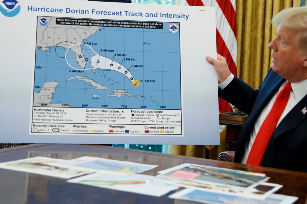
After days of claiming without evidence that Alabama was projected to be hit by Hurricane Dorian, President Donald Trump displayed an apparently doctored map in the Oval Office on Wednesday that showed Alabama to be within the storm’s path.
The map Trump displayed was the same as a model produced by the National Oceanic and Atmospheric Administration last week showing the hurricane’s projected path cutting through central Florida– with one key difference. Where the original projection ended, a smaller, black circle that appeared to be drawn in sharpie was produced to include Alabama in the model.
It’s probably fair to say much of the country has grown accustomed to a certain degree of absurdity surrounding Trump’s presidency, but once in a while, the Republican pushes the envelope in ways that raise concerns about his stability. Today was one of those days.
The Oval Office briefing started innocently enough, with Trump alerting reporters to the fact that he and his team wanted to give an update on storm preparations. But Trump then insisted on holding up a map from last week showing a trajectory of Hurricane Dorian that’s no longer accurate.
Right off the bat, this seemed unwise. Anyone watching the president during the briefing would see the image and receive outdated information. But Trump apparently wanted to show everyone an old image, not to serve any public interest, but because he’s still concerned about the pushback he received from his wrong tweet several days ago.
Indeed, the president didn’t just hold up an outdated image; he showed everyone an old map that featured a drawn-in bulge. Why was that there? Because in this crudely manipulated image, Alabama was at risk.
Or put another way, Trump displayed a dubious and unhelpful map in order to defend a false tweet from last weekend. Reality made the president look bad, so he gave reality a little touch-up with a black marker. At a separate event on opiods, Trump added. “I know that Alabama was in the original forecast, they thought it would get a piece of it…. They gave it a 95 percent chance.” Asked about the discrepancies between the original map and the one that had been crudely edited and shown to the public today, Trump said, “I don’t know. I don’t know.” NBC News’ report added, “Disseminating ‘knowingly’ false weather reports is against federal law. ‘Whoever knowingly issues or publishes any counterfeit weather forecast or warning of weather conditions falsely representing such forecast or warning to have been issued or published by the Weather Bureau, United States Signal Service, or other branch of the Government service, shall be fined under this title or imprisoned not more than ninety days, or both,’ 18 U.S. Code 2074 reads.”
Steve Benen is a producer for "The Rachel Maddow Show," the editor of MaddowBlog and an MS NOW political contributor. He's also the bestselling author of "Ministry of Truth: Democracy, Reality, and the Republicans' War on the Recent Past." Recommended

